Discing, shredding, prescribed fire and other disruptive yet helpful things at CREW

By Allison Vincent

Pine trees and understory growth after a prescribed burn at CREW Flint Pen Strand

Some recent guests on the CREW trails have inquired why they’re torn up? The long-range plans and efforts of the South Florida Water Management District (the District hereafter) can be a challenge on initial view, as “discing” and “shredding” projects can resemble hog damage or really knobby ATV tires wrecking havoc, both of which land managers set out to prevent. So why are they seemingly adding to the destruction? 

These tracks of discing and shredding are in fact intentional and well-planned measures designed to prepare for upcoming prescribed burns or chemical treatment, ultimately preventing vegetation from getting out of control. Vegetation can include non-native plants, shrubby understory, or native plants and trees that have grown out of balance with historical norms. Forestry science is behind the land management plans in place and its driving force is the long-range preservation goals of the CREW project. 

Even though the trails look less than ideal when torn up and the rough patches can make hiking and biking more difficult, just remember why CREW is here in the first place. It’s all about the water. These efforts benefit the watershed where we get our drinking water. Also, it’s good to think of the hierarchy of needs throughout the CREW lands like this: it begins with water and land management, then comes preserving habitat and then recreational opportunities for everyone.

Let’s discuss the management process we’re looking at on the trails. In order to perform a prescribed burn the District team must get approval from the state of Florida. Often this overlaps with an annual shredding plan, replete with maps and intensity, to clear the ground of any obtrusive vegetation before burns are scheduled. The burn prescription is based on several environmental factors, such as wind speed and direction, humidity and the burn history in the area. 

Assuming the burn prescription was approved the team, formed from several agencies including the Florida Fish and Wildlife Conservation Commission (FWC hereafter), must then coordinate their efforts and communicate their plans with the surrounding community. Working from a burn map (or planning map), the lead manager will direct the team to burn the fire line. In constant communication, the team stays on the fire from start to finish, following up the next several days for safety and reporting. 

Ultimately, the goal is to decrease the amount of understory vegetation in the CREW project, to prevent wildfires from getting out of hand, and encourage healthy native species growth. Many native fire-dependent species exist in the CREW lands, including the Slash Pine trees and Saw Palmetto which have evolved to withstand heat and benefit from fire. Prescribed burns also benefit the wildlife native to CREW, including the gopher tortoise, which prefers some open scrub to the encroachment of the long-living Saw Palmetto.

Hopefully, the next time you see the process or after-effects of the land management efforts to preserve these lands you will have a better understanding of their long range intentions. If you would like to learn more about this process, there are a few great resources found here. Always feel free to reach out to our office or that of the District with your questions.

History of Flint Pen Strand: Part Four

photos by Bill Zaino

by Jayne Johnston, Education Coordinator, CREW Trust

I sincerely hope you enjoyed the previous blogs in this series by our CREW Trust Volunteer, Nan Mattingly, and the people who provided support for the information she shared (Brenda Brooks, Executive Director, CREW Trust; Ben Nelson, CREW Trust chairman.)

Nan did a great job providing an eagle’s eye view of hydrologic restoration. The intent of this final blog in the series is to fill in some of the finer details. I hope as you’re driving to CREW, you take notice of the changing landscape around you, from the developed areas to our conserved and restored lands of the CREW Project.

Sunrise above the lakes at Flint Pen Strand

Let’s start with a liquid water molecule, which is 2 atoms of hydrogen and 1 atom of oxygen. H2O has cohesive properties, meaning the molecules bond tightly to each other. Liquid water molecules condense in the sky (clouds) and fall to the ground (rain). The land absorbs the liquid water through soils, roots, and leaves of plants. Absorption slows as soils become saturated over the rainy season. Molecules in marshes, sloughs, domes, and swamps bond with the falling molecules, volume increases, and water levels rise. Water molecules also interact with our ecosystems through evaporation – water becomes gas (think humidity!) – and transpiration (plant sweat from leaves). There is one state of water that CREW does not experience and one of the reasons so many of us live here and that is its frozen state more commonly known as snow and ice.

Water on the landscape moves from higher elevation (uphill) to lower elevation (downhill). Then gravity plays a role – the important role – of recharging the aquifer by pulling the water through the soils and the porous limestone (percolation) and into the aquifer where it is stored for later use.

Wading birds at the Flint Pen Strand Lakes

Water also moves in the path of least resistance on land. Before development, that would have been along the uneven landscape of rivers, streams, and creeks, created over 20,000 years by a changing climate. Post development – ditches, canals, or channels – were dug to drain water, creating dry land for buildings like where you and I live, work, and play. These paths concentrate the flow of water causing it to move away from the CREW Project. Sometimes this can happen too quickly for contaminants to be filtered, flooding to be controlled, or the aquifer to be recharged and less drinking water for people.

Water that is not absorbed and filtered by the soils, plants, and limestone, or deposited in ditches, canals, or channels, flows across the land in a thin sheet of water (sheetflow), to the Imperial River, then Fish Trap Bay (the southernmost end of Estero Bay) and into the Gulf of Mexico. Even estuaries like Fish Trap Bay and the Gulf of Mexico need freshwater because of the plants and animals living there. When water flows across the landscape, it can pick up speed and contaminants along the way, which is what the CREW Project attempts to mitigate.

Permeable roads allow water to absorb into the ground and flow “downhill”

Wetland restoration improves the functionality of ecosystems of the CREW Project by removing invasives and surfaces like roads that prevent water absorption. Additional benefits are flooding mitigation and wildlife protection. The CREW watershed lands are owned by the South Florida Water Management, Audubon’s Corkscrew Swamp Sanctuary, Lee County Conservation 20/20, Conservation Collier, and a few private inholdings. The ownership collaboration is why we call the CREW Watershed the CREW Project. Through these owners, the watershed will remain undeveloped in perpetuity. You can support our collective efforts through memberships and volunteering for the CREW Trust, supporting land purchase opportunities by government and nonprofit organizations, and speaking up on behalf of the land, the plants, and animals, to your family, friends, neighbors, and fellow citizens. Thank you for your support!  

History of Flint Pen Strand: Part One

photo by Michael Lund

Flint Pen Strand becomes part of the CREW Project

Volunteer Perspective Series

By Nan Mattingly

Have you hiked the trails of CREW Flint Pen Strand (FPS) yet? Seen a pair of ospreys fly overhead and heard their distinctive call? Enjoyed the serenity of walking alongside the Kehl Canal on the red trail? Watched the antics of shorebirds along the lakes on the eastern side? Identified any of the colorful wildflowers that grow throughout the 14,000-acre property?

If so, you and many hikers, equestrians, bicyclists, hunters, photographers, dog walkers and nature lovers owe a big thanks to the people, organizations and local and state governments who cooperated to acquire the land, restore its natural ability to collect and purify water to replenish the aquifers and develop the trails that we now enjoy.

To encourage you and your family to discover the beauty of FPS, we’ve written a series of blogs to tell you a little about the background of the establishment of FPS as part of the Corkscrew Regional Ecosystem Watershed (CREW) Project, the historical use of the land and the restoration of its wetlands.

Dwarf Cypress trees on the Yellow Trail North at Flint Pen Strand

The area now known as CREW Flint Pen Strand was, in the late twentieth century, a flat and flood-prone area. At that time, the land was in the beginning stages of development for single-family homes on five- to ten-acre plots. A small part of the land was already inhabited and was being used for pasture, row crops and other agricultural activities, and a mobile home park was situated within its boundaries.

But local officials, environmentalists and residents recognized that development was affecting surface water storage and the natural flow of water from the Lake Trafford area through Lee and Collier County and into the Imperial and Cocohatchee Rivers. Bonita Springs was experiencing increased flooding and contamination of surface and ground waters. After a great deal of tangling with red tape, many community hearings and various assessments, it was decided that it was critical to halt development and restore the ecosystem of the land to improve water quality and supply, reduce the threat of flooding and improve habitat for protected species and other wildlife.

Flint Pen Strand during the rainy season

Water quality testing at that time had revealed the undesirable effects of agricultural and residential use of the land. These activities added pollutants to the water and decreased the time that water could linger on the land, reducing the amount of water that seeped into the aquifer. This finding made the restoration project more urgent. 

An environmental assessment performed, as a part of the larger project by the U.S. Army Corps of Engineers in 1999, found that the restoration of FPS wetlands would reclaim habitat needed by several species, including wood storks, an endangered species at that time (now classified as threatened). Wood storks have extremely specific foraging requirements, and FPS promised to provide their essential needs for nesting and feeding. Consideration was also given to the Florida panther, its need for space to roam, and the numerous other species protected within their range, as well as the Florida black bear and the Big Cypress fox squirrel. The project also would aim to remove much of the exotic vegetation that had invaded the land, primarily melaleuca trees and Brazilian pepper bushes.   

Woodstorks and numerous other wading birds at Flint Pen Strand, November of 2019

In short, restoration of FPS promised considerable benefits for wildlife, vegetation and people.

If you look at a map of the CREW Project as it now exists, you’ll see that FPS is a key part of the project, adjoining CREW Bird Rookery Swamp and buffering Corkscrew Swamp Sanctuary. FPS comprises a large part of the 60,000-acre CREW Project. More importantly, FPS has become a key part of the protection of the 3-aquifers underlying the CREW Project – the aquifers that provide much of the drinking and general use water for southern Lee County and northern Collier County. The ongoing restoration of the wetlands and the landscape of FPS is now transforming this environmentally valuable property into a place that everyone can enjoy – a place that allows birds and many species to call it home and that will help keep us all supplied with drinking water.     

And if you want to see some evidence of whether or not this ambitious restoration project has achieved any of its goals, check out the weekly volunteer observation reports by a CREW Trust volunteer who records the type and number of species he encounters in his lengthy trail walks. Those observations are posted on the CREW Land & Water Trust Facebook page (@CREWTrust). Additionally, if you walk the Red Trail, you’ll find an area that some call the melaleuca graveyard. A lot of work by the South Florida Water Management District (SFWMD) has gone into the effort to kill those invasive trees that threaten native species. That work continues.  Keep an eye out for the next post in this series – it may surprise you, to learn who the earliest users of FPS lands and resources were and how they traveled to get there.

Scientists in the Field

Kathleen Smith with Florida Fish & Wildlife Conservation Commission is the lead wildlife biologist for the CREW WEA.

by Allison Vincent

CREW Trust Communications Director & Volunteer Coordinator

There is a lot of science that happens at CREW. Did you know that the Florida Fish and Wildlife Conservation Commission (FWC) employs two full time wildlife biologists to perform wildlife monitoring throughout the CREW project? Their research combines in-depth field work, data collection and long-term trend analysis to detect changes over time in animal and plant species because of land management activities.

Photo-monitoring, established at CREW in 2005 with additional sites added since then, is just one of many fascinating projects that take place in the interior lands of CREW. Stationary photo points are in three units of CREW where the Majority of the land management activities take place: Corkscrew Marsh, Cypress Dome Trails, and Flint Pen Strand.

FWC wildlife biologists Kathleen Smith and Lauren Plussa navigate the fire-breaker roads developed by the South Florida Water Management District through CREW Flint Pen Strand.

FWC biologists use a standardized data collection method at each photo point throughout the process. Starting with a map of the photo points, they embark early in the morning to beat the heat and the summer storms. On the route through north Flint Pen Strand, a swamp buggy is needed to reach interior photo points and a pole saw is required to clear and navigate the thick midstory of fast growing Florida foliage.

Lauren Plussa clears the overgrown path for our buggy to pass and for hunt permit holders that may use the same trail during the upcoming hunt season.

There is a lot that goes into photo-monitoring. The most important component involves photographing the vegetation in the exact same spot, twice a year (wet season and dry season) over an extended period of time. For each photo, biologists place the camera on a platform at a fixed height, and then using a 16.5-foot rope, biologists walk a field helper to the end of the rope, placing that helper at the same fixed distance away from the camera in each photo. This field helper holds a sign with the number and cardinal direction of each photo, as well as a vegetation measuring stick that measures the height of the surrounding vegetation. These photos serve as representative snapshots of vegetative changes on the CREW lands over time.

Biologists also use a densiometer which looks like a concave-shaped mirror that reflects the canopy cover above them to determine the density of tree canopy and mark changes in canopy density over time.

After collecting the data they return to the comfort of the office field station to compile the results and compare this year with previously collected data. The post-field work analyses is the more complex and time-consuming part of field work, but it provides a complete picture of the vegetative changes over time on the CREW Management Area

Not a wildlife biologist, but want to make a difference in the conservation? You can collaborate on an array of citizen science projects that contribute invaluable data to our understanding of the world. Here’s a curated list of organizations requesting your help:

  1. SciStarter provides a database of more than 3,000 vetted, searchable projects and events.
  2. NASA’s citizen science projects are collaborations between scientists and interested members of the public.
  3. Citizen Science at NOAA– There are dozens of citizen science projects within NOAA that provide opportunities for people to engage in scientific investigation.
  4. Join in the Smithsonian Research Mission– Depending on your interests, you can help sustain species around the globe and even solve mysteries of the planets and stars!
  5. Florida Fish and Wildlife Conservation Commission– Citizen science is a smart, collaborative strategy that enhances the FWC’s ability to conserve Florida’s diversity of fish and wildlife species and their habitats.
  6. Nature’s Notebook – Nature’s Notebook is an off-the-shelf program appropriate for scientists and non-scientists alike, engaging observers across the nation to collect phenology observations on both plants and animals.
  7. Globe at Night – Globe at Night is an international citizen-science campaign to raise public awareness of the impact of light pollution by inviting citizen-scientists to measure & submit their night sky brightness observations.
  8. Collect Weather Data – CoCoRaHS (pronounced KO-ko-rozz) is a grassroots volunteer network of backyard weather observers of all ages and backgrounds working together to measure and map precipitation (rain, hail and snow) in their local communities.
  9. BioBlitz – A BioBlitz is an event that focuses on finding and identifying as many species as possible in a specific area over a short period of time. 
  10. Christmas Bird Count (CBC) – participate in the largest and longest citizen science count of birds in the world. 
  11. iNaturalist – Love learning about the outdoor world? Let iNaturalist help you identify species while also contributing to a worldwide collection of scientific observations.
  12. IveGot1 – Help FWC track and manage the populations of nonnative and invasive species by reporting sightings with photos via app, phone call, or online report.

All CREW Trails Closed Effective April 4th

April 3, 2020

As part of ongoing efforts to help prevent the potential spread of COVID-19 and protect public safety, the South Florida Water Management District (SFWMD) will temporarily close the all CREW trails, effective at 6 p.m. on Saturday, April 4, 2020.

Closure includes Bird Rookery Swamp, Flint Pen Strand, Cypress Dome and CREW Marsh trails.

The District follows the lead of local governments that have issued Safer at Home orders in their communities and guidance from the Centers for Disease Control and Prevention (CDC) and the Florida Department of Health.

Read the official post from South Florida Water Management District blog: https://www.sfwmd.gov/news/sfwmd-temporarily-closing-crew-lands-southwest-florida-reduce-potential-spread-covid-19

White Pelican Party

As the water dries down at CREW’s Flint Pen Strand trails, an abundance of wading birds have become regular visitors to the lakes. You can access the lakes two different ways: by hiking from the Main Parking lot or parking in the smaller Lakes Parking lot adjacent to the lakes. If you want to see these birds arrive early for sunrise or later for sunset. Take your time approaching these flighty hunters and you will be rewarded with views perfect for unbelievable photographs. For some inspiration, take a look through this collection from CREW Trust volunteer, Bill Zaino’s recent photos capturing White Pelicans, Roseate Spoonbills, Woodstorks, Tricolored Herons, Great Egrets, Snowy Egrets, Limpkins and Greater Yellowlegs .

CREW and You, part 4: WHERE

Map of CREW

This is part 4 of a 6-part series on the Who, What, When, Where, Why and How of the CREW Land & Water Trust.

Map of CREW
The CREW Project

It’s pretty often that we get a phone call at our office and someone says, “Where are you located?” or “Where is the trail?”

So let’s cover that today.

WHERE, exactly, is the CREW Land & Water Trust located?

At a field station. A super, top-secret field station, with radiactive sandhill cranes that guard the entrance. (Just kidding about all of that except for the field station part.)

The CREW Trust shares an office with two of our partners in the CREW Project – South Florida Water Management District and Florida Fish & Wildlife Conservation Commission. Because this is a shared office, and we have no trails (really, none – it’s very boring), we use our address for mail only. If you do look us up on Google maps based on our mailing address, we appear to be somewhere in the middle of some strange fields off of Corkscrew Road.

Basically, where WE are isn’t as important as where the CREW Project is.

The CREW Project is a 60,000-acre watershed that spans Lee and Collier Counties. There are four trail systems that are open to the public for various recreation opportunities.

The CREW Trail Systems: A – CREW Marsh Trails; B – Cypress Dome Trails; C – Bird Rookery Swamp; and now a trail has opened in Flint Pen Strand.

The CREW Marsh Trails (4600 CR 850 (Corkscrew Road), Immokalee, FL 34142 ) were the first trails to open within the CREW Project and feature 5.5 miles of looped trails. The trails are located in Collier County and meander through pine flatwoods, sawgrass marsh, oak hammock and popash slough ecosystems.

The Cypress Dome Trails & Caracara Prairie Preserve (3980 CR 850 (Corkscrew Road), Immokalee, FL 34142) are located in Collier County near the Lee County border. The Cypress Dome Trails offer 6 miles of looped trails and connect to the Caracara Prairier Preserve, which is owned and managed by Conservation Collier.

Bird Rookery Swamp Trail (1295 Shady Hollow Boulevard, Naples, FL 34120) is an approximately 12 mile trail located in Collier County. The trail features a shell path, short boardwalk and grassy tram – a remnant of its logging history.

The first trail in Flint Pen Strand opened in November 2018 and more are in development. The 1.5-mile red trail offers views of the Kehl Canal along with sections of seasonal marsh and hydric pine.

Our season review: a letter from the Executive Director

Flint Pen Strand – photo by Klaus Harvey

As our weather turns warmer and rainy season is on the horizon, I find myself reflecting on this past season.

This year the CREW Trust celebrates its 30th anniversary. So much has been accomplished in that time frame, with much more yet to be completed. Of the 60,000-acres within the borders of the watershed, almost 55,000-acres within the Corkscrew Regoinal Ecosystem Watershed (CREW) have been acquired. We continue to pursue our mission of preserving and protecting water, our most valuable natural resource, through working with our partners, specifically Lee County’s Conservation 20/20 program and Collier County’s Conservation Collier.

Education is a key component of ensuring that generations today and those that follow will connect with the land and the wildlife within the CREW Project borders and understand the value of the watershed. We are thankful for the visitors, residents, schools and CREW Trust members who participated in this season’s programs and visited the four trail systems.

This season saw the opening of the fourth and final CREW Project trail system – Flint Pen Strand. Our volunteers have worked for several years to create and mark the first two trails and continue to work on additional trails. Our Board of Trustees have been key players in this process through their work behind the scenes to assist the CREW Trust and our partners in making this exceptional area open to the public.

I have spent time over the last few weeks exploring the yellow loop in Flint Pen Strand. As I stood amidst the dwarf cypress and blooming bladderwort north of Kehl Canal, I thought of my dear friend Jim Goodwin and the hours he put into making Flint Pen Strand a reality. There is no other place in CREW like it, and I’m thankful to our volunteers, members, Board of Trustees and friends who have helped open this fourth trail system so we can all share in the beauty of the watershed.

Summer is our time to plan for next season, and I look forward to seeing you on the trails and thank you for continuing to support the CREW Trust and share in the remarkable beauty that is the CREW Project.

Brenda Brooks

Executive Director

CREW Land & Water Trust

CREW Trust Executive Director Brenda Brooks

Know before you go: Holiday Hiking

Looking for some vitamin D therapy this holiday week? The trails are waiting and wild Florida is happy to see you!

But before you slip on those flip flops (please no) and head out to one of the CREW Trails, check out a few of the things you might want to know before you go. It will save you the pain of fire ant bites if you DO opt for flip flops (again, please please please no).

For trail conditions, click here.

CREW Marsh Trails

Address: 4600 CR 850 (Corkscrew Road), Immokalee, FL 34142

Hours: Open every day, one hour before sunrise to one hour after sunset

Cost: Free; donations accepted

Facilities: Port-o-potty in parking lot; no trash cans – please pack it in, and pack it out

Miles of trails: 5.5 combined miles of looped trails

Wear: Closed-toe shoes, socks; pants advised if grass is high (as of 12/24/2018 grass is only high along Alternative Marsh trail)

Pack: Water, bug spray (if desired), snack

Safety: Fire ants do nest in disturbed areas along the edges of the trails, so please walk in the middle of the trails.

Can’t Miss Spot: Head out to the Observation Tower, which overlooks the 5,000-acre sawgrass marsh. The marsh is a key part of the watershed and helps filter the water that eventually ends up in the aquifer (and then, in your glass!)

Notes: Do not trust Google maps! Instead, follow these directions:

From Naples/Bonita Springs/S. Fort Myers: Travel  I-75 N to exit 123 (Corkscrew Rd.).  Go 18 miles east on Corkscrew Rd.  You will pass the CREW Cypress Dome Trails.  Go another 4 miles and you will see the CREW Marsh Trails on your right.  Look for the brown road signs.

From N Ft. Myers/Charlotte County/Lehigh Acres: travel I-75 to exit 138 (the ML King/S.R. 82 exit).  Travel east on S.Rr 82 toward Immokalee for 20 miles.  Watch for a small blue C.R. 850 sign, then turn right on C.R. 850 (Corkscrew Rd.).  The Marsh Trails are apporximately 2 miles down the road on your left.  Look for the brown road signs.
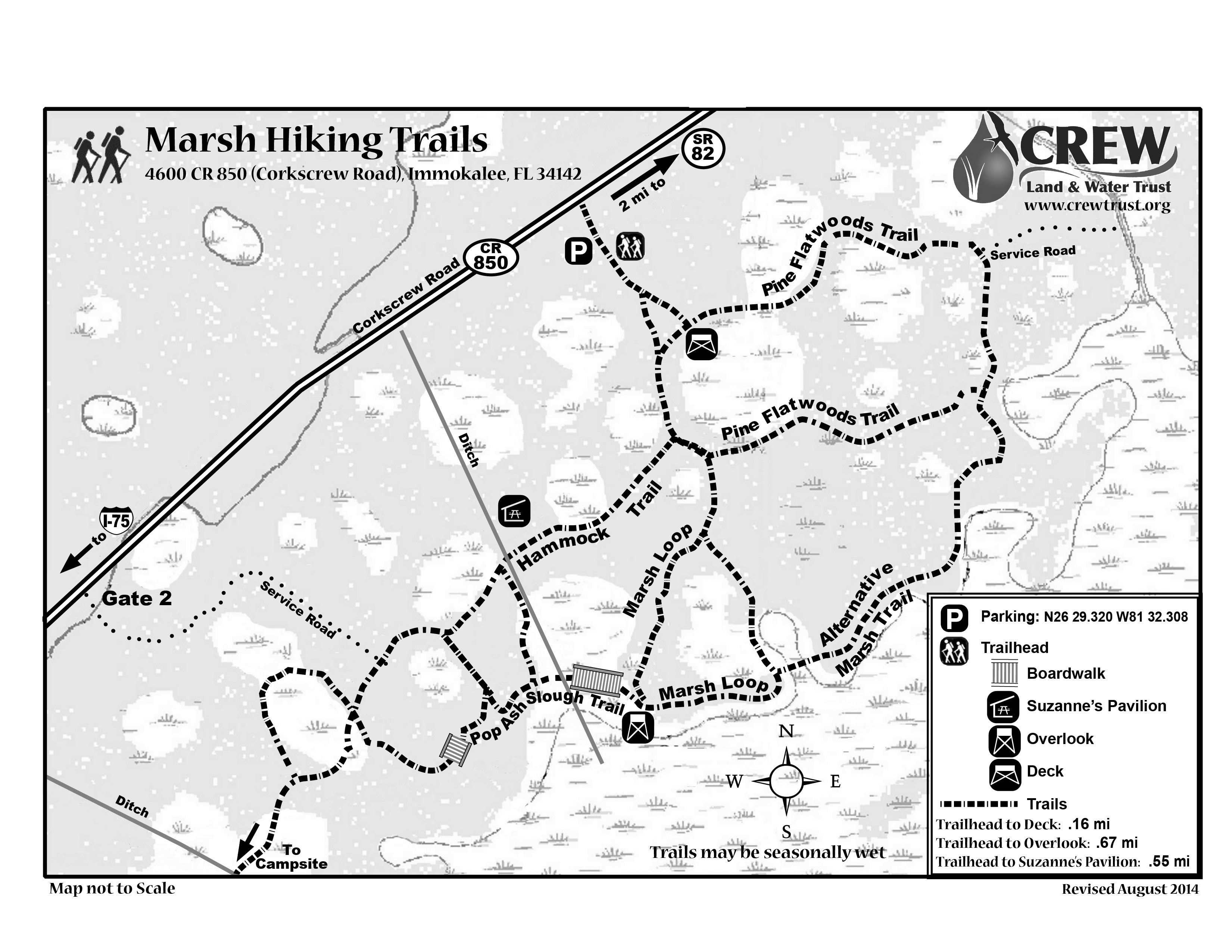
Trail Map:

Cypress Dome Trails and Caracara Prairie Preserve

Address: 3980 CR 850 (Corkscrew Road), Immokalee, FL 34142

Hours: Open every day, one hour before sunrise to one hour after sunset

Cost: Free; donations accepted

Facilities: Port-o-potty located close to parking lot on the beginning of the green loop (head toward Jim’s Pavillion)

Miles of trails: The Cypress Dome Trails offer six combined miles of looped trails and connects to Caracara Prairie Preserve, which is owned and managed by Conservation Collier.

Wear: Closed-toe shoes, socks and long pants recommended, especially as there may be muddy conditions in the middle of the Wild Coffee Trail (the farthest part of the white trail).

Pack: Water, snacks, bug spray. Bring extra water if you plan on heading out to Caracara Prairie Preserve as well.

Safety: December is small game hunting season and there are hunters on the property; hunting is monitored by FWC. Fire ants nest in distrubed areas along the sides of the trails, so walking in the middle of the trail is advised.

Can’t Miss Spot: Head out on the green trail (turn right from the trailhead) and it will wind around, past the pavillion, and then meet up with the blue trail (a shortcut). This is marker 4 on the map, and in front of you will be a beautiful Cypress Dome. It is almost dry this time of year, and you can see the water level marks on the bark. Take a photo of yourself or a family member next to the cypress tree so you can see how high the water gets in that area during rainy season!

Notes: Again, don’t trust Google Maps. Follow these directions:

From Naples/Bonita Springs/S. Fort Myers – Travel I-75 N to exit 123 (Corkscrew Rd.). Travel 14 miles east on Corkscrew Rd. The Cypress Dome Trails will be on your right just past a big curve to the left (north). Look for the brown trail signs.

From N Ft. Myers/Charlotte Co./Lehigh Acres: Travel I-75 to exit 138 (the ML King/S.R. 82 exit). Turn left (east) off the ramp. Travel 20 miles toward Immokalee (east) on S.R. 82. Turn right on C.R. 850 (Corkscrew Rd.). You will pass the CREW Marsh Trails at the 2-mile mark. Continue for 4 more miles. The Cypress Dome Trails will be on your left. Look for the brown road signs.

Trail Map:

Flint Pen Strand Trails

Address: 15970 Bonita Beach Road, Bonita Springs, FL 34135

Hours: Open every day, one hour before sunrise to one hour after sunset

Cost: Free; donations accepted

Facilities: One port-o-potty located in the parking lot. No trash cans; pack it in, pack it out.

Miles of trails:  At this early stage, there is one trail open – the Billy G. Cobb Memorial Trail (red trail). It is approximately 1.5 miles long with a blue shortcut trail.

Wear: Closed-toe shoes, socks. Long pants if grass is long but at this time the grass should be short.

Pack: Water, bug spray.

Safety: This trail is not flat and has a lot of terrain changes. Fire ants are a hazard as they like to nest in disturbed areas along the trail.

Can’t Miss Spot: The Melaleuca ghost forest, an area of invasive trees that were treated years ago and are now dead. This area shows what happens when you remove the invasives and allow the land to heal itself, and you will spot young slash pine that are growing and will eventually help this spot return to a hydric pine flatwood.

Notes: Park in the parking lot (and not along the side of Vincent Road). Stick to the marked trails at this time, as some of the surrounding area is privately owned.

Trail Map:

Bird Rookery Swamp Trails

Address: 1295 Shady Hollow Boulevard, Naples, FL 34120

Hours: Open every day, one hour before sunrise to one hour past sunset

Cost: Free; donations accepted

Facilities: Two port-o-potties in the parking lot; no trash cans – pack it in, pack it out

Miles of trails: One almost-13-mile loop. There are no shortcuts back to the parking lot, nor are there any vehicles to come get you if you go out too far and are too tired to walk back.

Wear: Closed-toe shoes, socks, bug spray.

Pack: Snacks and plenty of water, especially if you are going to do the full loop. The swamp is quite humid and you can get dehydrated quickly on a warm day.

Safety: Turn around before you feel tired. This is very important at this trail system, as we have had people head out too far, then decide they cannot walk back to the parking lot – and their only option is to call 911.

Also, this trail is home to numerous alligators. Read all alligator safety signs – you will pass several in the parking lot. Remember this is their home, and you are a visitor. Turn around and go the other way if an alligator is on the path. You may not throw rocks or harass the alligators; if you see someone doing this, call FWC law enforcement.

The walking of dogs/pets is NOT recommended at this trail due to the presence of alligators.

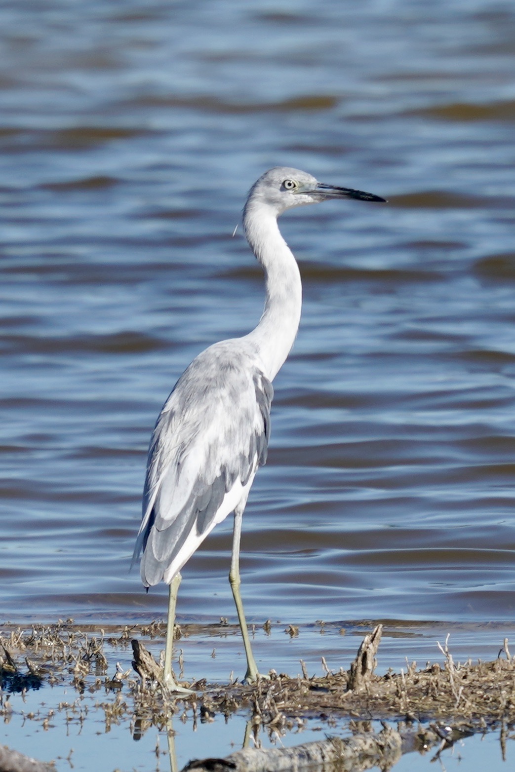
Can’t Miss Spot: The lake at the culvert, just past the boardwalk. You may see alligators, great white egrets, herons, roseate spoonbills and the occasional limpkin feeding in the water.

Notes: Please read all signs and safety information. For first time visitors, a short, easy walk is to head out to the short boardwalk, walk to the first pond, then turn around and head back. This will be around a mile and you will see cypress trees, red maple, wildflowers, ferns, air plants, migratory song birds, herons and more.

Trail Map:


BRS sign

CREW Flint Pen Strand Trails

Physical Address: 15970 Bonita Beach Road, Bonita Springs, FL 34135

Hours: One hour before sunrise to one hour after sunset

Trails/Facilities: Free – donations appreciated, Open to public

Click to Download: CREW FPS Trail Map

Map created by CREW Trust volunteer Wendy Richardson


 Activities:

*There are private properties near the CREW Flint Pen Strand Hiking Trails. The public should remain on marked trails and not enter areas marked as private property.

From Fort Myers: From I-75 S, take exit 116 and turn east on Bonita Beach Road. Travel approximately 3.8 miles and turn left onto Vincent Road. The trail head and main parking lot are on the left. Continue further down Vincent Road and make your first right for the Pine parking lot. A third parking option may be reached by making an immediate right after turning left off of Bonita Beach Road. 

From Naples: From I-75 N, take exit 116 and turn east on Bonita Beach Road. Travel approximately 3.8 miles and turn left onto Vincent Road. The trail head and main parking lot are on the left. Continue further down Vincent Road and make your first right for the Pine parking lot. A third parking option may be reached by making an immediate right after turning left off of Bonita Beach Road.

What you need to know about the Purple Trail